How Cartographic Symbols Can Turn You Into a Map-Reading Mastermind!
Have you ever puzzled over the cryptic cartographic symbols spread across a map?
Whether you’re a hiking fan tracing trails, a curious traveler plotting your next journey, or a geography student keen to master the language of maps, you’ve likely encountered these enigmatic markers.
This article demystifies the world of cartographic symbols, offering a comprehensive guide to their history, meaning, and how they vary globally.
Get ready to enhance your map-reading skills and navigate the world more confidently.
Continue reading to unlock the secrets of cartographic symbols and enrich your understanding of this universal visual language.
Let’s get started!
Here’s What You Will Find
Key Takeaways
Cartographic Symbols
Universal Visual Language: Cartographic symbols are not just tools for individual explorers or local planners; they’re the universal visual language that connects people across the globe, transcending language and cultural barriers.
Diverse Categories, Unified Understanding: From pinpointing a landmark to outlining a nation’s borders, these symbols bring diverse geographic information into a unified understanding, essential for local familiarity and global exploration.
Essential for Navigation and Insight: These symbols do more than guide—they provide insight into the environment, cultural landmarks, and the human impact on the landscape, making them indispensable for a wide array of practical applications and strategic planning.
Adaptability in the Digital Era: As digital mapping technologies advance, cartographic symbols adapt to new mediums, ensuring their role in global connectivity and understanding remains as relevant as ever, from paper maps to the most advanced GPS technologies.
What Are Cartographic Symbols?
A cartographic symbol is a graphic sign used on maps to represent a real-world phenomenon or feature. It conveys information through its shape, color, size, and placement. These symbols are part of a visual language that allows us to navigate the intricacies of our planet’s landscape on paper or digital screens.
Whether it’s a simple dot marking the location of a city, lines tracing the vast networks of roads, or shaded areas differentiating between land uses, each symbol is a key to unlocking the geographical secrets of an area. As we interpret these symbols, we transform abstract representations into meaningful knowledge about our world.
A cartographic symbol is a graphical representation used on maps to denote a particular feature or attribute. These symbols fall into three primary categories: point symbols, which represent features too small to be depicted to scale (like a building or a well); line symbols, which illustrate linear features (such as roads or rivers); and area symbols, which cover features that occupy a significant space (like forests or lakes).
But why do we need these symbols? Imagine trying to describe the entire layout of a city using only text. Not only would it be a logistical nightmare, but it would also be nearly impossible for someone to visualize. Cartographic symbols condense complex information into easily recognizable icons, making maps accessible and understandable to everyone, regardless of language.
What is Cartography Symbolization?
Cartography symbolization refers to using various symbols to represent geographical information and features on a map. This process involves selecting and designing icons, lines, colors, and patterns to effectively communicate the presence, location, and characteristics of physical, cultural, and abstract phenomena on the Earth’s surface.
Symbolization is a crucial aspect of cartographic design, as it directly influences a map’s readability, interpretability, and overall effectiveness in conveying spatial information.
By employing a standardized set of symbols, cartographers enable map users to quickly recognize and understand the represented features without needing extensive descriptions. This visual shorthand facilitates navigation, exploration, and analysis of geographical data, making complex spatial relationships and patterns more accessible and interpretable to a broad audience.
Understanding Map Symbols
Navigating the Cartographic Alphabet:
Embarking on a journey through a map is akin to reading an epic tale where each symbol contributes a crucial plot point to the story of the terrain.
These symbols, the very alphabet of cartography, allow us to translate abstract geographical data into tangible knowledge that guides our exploration of the physical world. From the smallest park bench to the vast expanse of the Sahara, cartographic symbols serve as the lexicon for adventurers and planners alike.
As we explore the rich vocabulary of map symbols, we unlock the ability to traverse diverse landscapes, understand human civilization’s imprint, and anticipate Mother Nature’s whims. Join us on a fascinating expedition across the tapestry of maps, where each symbol is a landmark, a chapter, and a signpost in our planet’s narrative.
Point Symbols
Point symbols are the cartographic dots on the map that pinpoint the precise location of a feature too small to depict at the map’s scale. Think of them as the full stops in a landscape sentence, indicating where something of note is situated. A classic point symbol is the triangle that marks a mountain peak, alerting hikers and climbers to the summit’s location.
Line Symbols
Line symbols are the connectors, the cartographic strokes that draw the relationship between two points. They outline roads, rivers, and boundaries, acting as the veins through which the lifeblood of movement and natural processes flow. An example would be the solid lines indicating highways, which are essential for road-trippers and commuters plotting their routes.
Area Symbols
Area symbols fill the cartographic canvas, coloring the spaces to show expansive features like forests, lakes, or urban areas. These background shades set the scene for the map’s theme. A common area symbol uses green to represent a forested region, offering nature enthusiasts and conservationists a visual cue.
Color Codes
Color codes on maps are like a painter’s palette, providing instant visual cues about the environment. Blue is universally used for water and easily distinguishable for sailors and anglers seeking the sea or rivers.
Topographic Symbols
Topographic symbols give maps a three-dimensional quality, illustrating the undulating terrain of the Earth’s surface. They’re the contours of the Earth’s face, showing ridges, valleys, and plains. Contour lines are typical topographic symbols, each representing a specific elevation above sea level.
Hydrographic Symbols
Hydrographic symbols chart the watery parts of the world, detailing the ebbs and flows of aquatic features. Sailors and marine conservationists might look for the anchor symbol, marking a marina or safe anchorage on nautical charts.
Vegetation Markers
Vegetation markers provide a botanical overview, highlighting the lush tapestry of plant life. For instance, a cluster of small tree icons may denote a copse orchard, which is essential information for nature lovers and agricultural planners.
Cultural Symbols
Cultural symbols on maps mark the human touch on the landscape, from historical sites to places of worship. For example, the cross symbol might represent a church, a guidepost for both the spiritual seeker and the cultural tourist.
Boundary Markers
Boundary markers draw the invisible lines that define political or administrative territories. Dotted lines often depict these, clarifying the jurisdictional landscape for policymakers and the civically curious.
Road and Pathway Signs
Road and Pathway signs are the cartographer’s directions, showing the arteries and capillaries of transportation. Broad, bold lines for major highways are vital for logistics professionals and the everyday commuter alike.
Building Icons
Building icons are the cartographic pins for structures, from the Eiffel Tower to your local post office. These icons are key landmarks, providing navigation points and identifying essential services.
Land Use Indicators
Land Use Indicators categorize the map’s area by its predominant human usage—residential, commercial, agricultural, or industrial. Shading a region as light yellow might indicate a sandy desert, which is essential for environmental scientists and developers.
Recreational Symbols
Recreational symbols flag up leisure spots, from national parks to ski resorts. A tent symbol, for instance, could represent a campground, a beacon for the adventurous camper.
Hazard Icons
Hazard Icons are the warning signs on the map, alerting potential dangers such as flood zones or earthquake faults. A symbol like a flame could denote areas prone to wildfires, essential information for emergency services and residents in vulnerable regions.
Weather and Climate Symbols
Weather and Climate Symbols illustrate meteorological and climatic conditions, such as prevailing winds or rainfall patterns. A snowflake icon may mark a region known for its cold, snowy climate, information that’s crucial for tourists planning their wardrobe and activities.
These cartographic symbols serve as a visual glossary, allowing us to read the Earth’s geography clearly and precisely. Each symbol is a concise narrative element that, together with others, tells the comprehensive story of our complex and multifaceted world.
Decoding the Symbols
How to Read a Map
Learning to read a map is like learning to read a new language, but instead of words and grammar, you’re dealing with icons and legends. The legend, or key, is your Rosetta Stone when deciphering a map. It tells you what each symbol represents, from the smallest footpath to the broadest river.
For those new to the world of cartography, here are a few tips to get you started:
- Start with the legend: Before trying to interpret the map itself, familiarize yourself with the symbols listed in the legend.
- Look for patterns: Many symbols are designed to be intuitive. For example, blue typically represents water features, while green indicates vegetation.
- Practice makes perfect: The more you work with maps, the more familiar you’ll become with the symbols and their meanings.
Understanding common cartographic symbols can turn a bewildering array of lines, shapes, and colors into a clear and informative guide to the world around you.
Whether hiking through a national park or navigating the streets of a foreign city, a good map can be your most valuable tool.
The Art and Science Behind Creating Cartographic Symbols
Designing cartographic symbols is a delicate balancing act between art and science. Cartographers must create symbols that are not only visually appealing but also universally understandable. This requires a deep understanding of human perception, cultural differences, and map-making’s technical limitations.
One of the primary considerations in symbol design is color. Colors can convey a wealth of information on a map; for example, blue for water bodies, green for vegetation, and brown for elevation contours.
However, color must be consistent and logical, as varying shades can represent different features or intensities.
Shape and size are also crucial. Symbols must be distinct enough to be easily differentiated at a glance but not so complex that they become cluttered or confusing. A symbol’s size often indicates the feature’s importance or scale, guiding the map reader’s attention to key points of interest.
Designing these symbols involves rigorous testing and refinement. Cartographers use scientific research and artistic intuition to develop symbols that accurately convey information while remaining aesthetically pleasing. The goal is to create a set of symbols that work together harmoniously to tell the story of the landscape.
Cartographic Symbols and Their Meanings
Each cartographic symbol is a piece of the larger puzzle: a map. Understanding these symbols allows us to interpret the landscape they represent. For instance, a simple triangle might denote a mountain peak, while a crossed square could indicate a church or other place of worship.
Topographic maps show the physical features of the landscape and use a wide array of symbols to depict elevation changes, water bodies, vegetation, and human-made structures. Thematic maps, however, focus on specific topics like population density or weather patterns and often use a more specialized set of symbols to represent data.
In urban areas, maps might use symbols to show locations of interest, such as schools, hospitals, and public transportation hubs. In contrast, rural maps might emphasize natural features like rivers, forests, and mountains. Nautical maps, used for maritime or aerial navigation, employ different symbols to guide travelers safely through waterways or airspace.
What are the 5 Cartographic Design Elements?
The five key elements of cartographic design are essential components that work together to make a map informative and visually compelling.
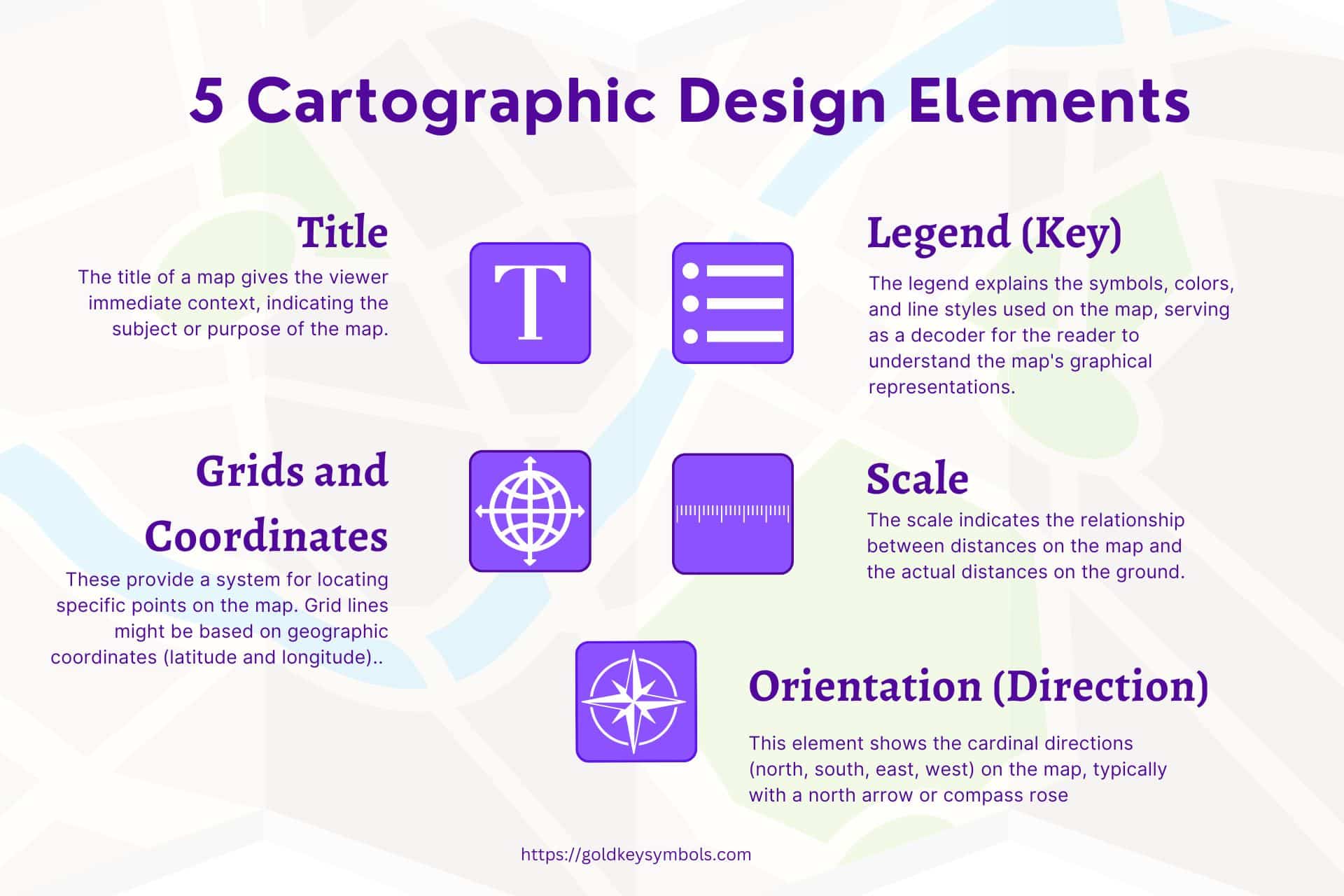
These elements guide the creation and interpretation of maps, ensuring they effectively communicate geographical information. Here they are:
- Title: The title of a map gives the viewer immediate context, indicating the subject or purpose of the map. It’s typically placed prominently at the top or strategically where it catches the eye first.
- Legend (Key): The legend explains the symbols, colors, and line styles used on the map, serving as a decoder for the reader to understand the map’s graphical representations. It’s essential for making the map’s information accessible and clear.
- Scale: The scale indicates the relationship between distances on the map and the actual distances on the ground. It can be represented numerically (e.g., 1:100,000) or graphically with a scale bar, helping users gauge distances and the size of geographical features.
- Orientation (Direction): This element shows the cardinal directions (north, south, east, west) on the map, typically with a north arrow or compass rose. It helps the viewer understand the map’s alignment with the real world.
- Grids and Coordinates: These provide a system for locating specific points on the map. Grid lines might be based on geographic coordinates (latitude and longitude) or systems like UTM (Universal Transverse Mercator). They are crucial for precise navigation and location identification.
Together, these elements form the backbone of cartographic design. Cartographic design blends art and science to craft maps that are accurate, engaging, and easy to use.
The Role of Cartographic Symbols in Digital Mapping Technologies
The digital revolution has dramatically expanded the capabilities of maps and, by extension, the symbols they use. Digital maps can be zoomed and scrolled, revealing different levels of detail and a broader range of symbols as needed. They can also be dynamically updated, allowing real-time information to be incorporated into the map.
Digital mapping technologies have introduced new symbols for features such as traffic conditions, public transit routes, and even the real-time location of buses and trains. These symbols must be designed to be clear and understandable at various scales and resolutions, from a smartphone screen to a large desktop display.
Despite these advancements, the challenge remains to design symbols that are intuitive and accessible to a global audience. As maps become more interactive and integrated with other digital services, the importance of effective symbol design only grows.
Cartographic Symbols Around the World
A Cultural Perspective
The design and interpretation of cartographic symbols are not universal; cultural differences can influence how symbols are understood. For example, while red may signify danger or stop in many Western cultures, it represents good fortune in China. Cartographers must be mindful of these cultural nuances when creating maps intended for an international audience.
Studying unique cartographic symbols from different cultures reveals fascinating insights into how people relate to their environment.
For example, Indigenous maps might employ symbols representing seasonal changes, spiritual significance, or traditional land use patterns, offering a unique perspective on the landscape.
Localizing maps and their symbols for different regions is essential to ensure they are valuable and meaningful to all users. This process involves translating text and adapting symbols to align with local conventions and cultural expectations.
The Future of Cartographic Symbols
Trends and Predictions
As we look to the future, the field of cartography and the symbols it uses are poised for further evolution. Emerging technologies like augmented reality (AR) and virtual reality (VR) offer new ways to interact with maps, potentially introducing a new set of symbols and markers.
These technologies could allow us to overlay digital information directly onto the physical world, creating an immersive mapping experience.
The increasing availability of big data and machine learning technologies also has the potential to revolutionize map-making and the symbols used. Maps could become more personalized, displaying symbols and information tailored to users’ needs and preferences.
Despite these technological advancements, the fundamental principles of symbol design—clarity, consistency, and universality—will remain paramount. As cartographic symbols evolve, they will become more integrated into our daily lives, helping us navigate an increasingly complex world.
The History and Evolution of Cartographic Symbols
The story of cartographic symbols is as old as map-making itself, tracing back to ancient civilizations. The earliest maps, drawn on clay tablets or papyrus, used simple pictorial symbols to represent landforms, water bodies, and human settlements.
These symbols were the ancestors of the modern cartographic language, evolving over centuries as mapping techniques and technologies advanced.
Thanks to the invention of the printing press, the Renaissance marked a significant turning point in the development of cartographic symbols. This era saw the standardization of symbols as maps became more widespread and accessible.
The 19th and 20th centuries brought further innovations, including the introduction of color printing, which allowed for more detailed and differentiated symbols.
In the digital age, the evolution of cartographic symbols has continued at an unprecedented pace. The advent of GIS (Geographic Information Systems) and online mapping tools like Google Maps has transformed how we create and interact with maps.
Today’s digital maps can display an astonishing level of detail, from traffic conditions to weather patterns, all represented through a sophisticated system of symbols.
FAQs about Cartographic Symbols
Can cartographic symbols vary from one map to another?
Yes, while many symbols are standardized, especially on topographic and nautical maps, cartographers may use different symbols based on the map’s purpose or design preferences. It’s always best to consult the map’s legend for accurate interpretation.
How are new cartographic symbols created?
New symbols are often developed in response to the need to represent new features or data types, especially with the advent of digital mapping technologies. This process involves cartographic organizations’ design, testing, and sometimes standardization efforts.
Are there any universal cartographic symbols?
Some symbols, like those for major landmarks, airports, and certain natural features, are widely recognized and used globally. However, variations can still exist due to cultural differences or mapping conventions.
How can I learn more about cartographic symbols?
Many resources are available for those interested in deepening their knowledge of cartographic symbols, including cartography textbooks, online courses, and websites dedicated to mapping and GIS. Practice reading different types of maps and their legends is also a great way to become more familiar with various symbols.
Last Thoughts
Cartographic symbols unlock the vast amounts of information contained within maps. They allow us to traverse continents, explore the depths of the oceans, and navigate the complexity of urban landscapes—all from the comfort of our homes.
As we have seen, these symbols are much more than mere markings on a map; they are a universal language that bridges cultures, technologies, and time periods.
As you step out into the world, map in hand (or phone), appreciate the intricate dance of symbols that guide you. The next time you successfully navigate a tricky route, why not share your cartographic victory with friends?
After all, every explorer deserves a moment of fame, even if it’s just to find the best coffee shop in town.
So, whether you’re a seasoned cartographer or a casual map enthusiast, remember that each symbol has a story. And who knows? Perhaps you’ll be inspired to explore new horizons, armed with the knowledge that the world is at your fingertips through cartographic symbols.
Before You Go
If you’ve ever found joy in tracing the lines of a map or discovered the hidden stories behind the symbols scattered across its surface, why keep it to yourself?
Maps are a treasure trove of knowledge, adventure, and history; sharing them enriches others’ lives too.
So, whether it’s to assist a friend in planning their next expedition or sparking curiosity in a classroom, pass on this cartographic narrative.
Who knows, the next time you’re on a road trip or exploring a new city, the knowledge you’ve shared could open up a whole new world for someone else, just as it has for you.
Spread the word, share the map, and let’s navigate this fascinating world!
More on Cartographic Symbols
- Point Symbols
- Line Symbols
- Area Symbols
- Color Codes
- Topographic Symbols
- Hydrographic Symbols
- Vegetation Markers
- Cultural Symbols
- Boundary Markers
- Road and Pathway Signs
- Building Icons
- Land Use Indicators
- Recreational Symbols
- Hazard Icons
- Weather and Climate Symbols
More on Symbols
History of Symbols: How Ancient Marks Shape Our Modern World!
From Cave Walls to Emojis—A Journey Through Time Have you ever wondered about the history of symbols? Maybe you’ve wondered about their global variations or how they’ve shaped our world. Prepare to have your curiosity …
Check it Out!
Tattoos and Their Secret Powers: How Ink Can Change Your Life!
Exploring the Art, Meaning, and Culture of Ink! Are you intrigued by tattoos? Are you curious about the stories they tell and the intricate details they contain? Look no further. You might be wondering about …
Check it Out!
Masonic Symbols Unlocked: Discover the Secret Meanings Behind the World’s Most Mysterious Icons!
The Hidden Powers and Ancient Secrets You Never Knew! Are you intrigued by masonic symbols and their profound meanings? Perhaps you’ve seen the square, compasses, or the all-seeing eye and wondered about their significance? Thankfully, …
Check it Out!
Military Insignia: Unlock the Hidden Meanings Behind These Powerful Symbols
From Zero to Hero: Uncover How Military Insignia Define Power and Prestige Are you curious about the meaning behind military insignia or rank emblems? Have you ever wondered about their significance or history? This comprehensive …
Check it Out!